Consuming Data from a RESTful Web Service
As an example of a RESTful web service, let’s add some more information to our list of restaurant health inspection metadata from a previous exercise.
We’ll use a common, public API provided by Google.
Geocoding
Geocoding with Google APIs
https://developers.google.com/maps/documentation/geocoding
Open a python interpreter using your souptests virtualenv:
[souptests]
heffalump:souptests cewing$ python
Then, import the requests library and prepare to make an HTTP request to
the google geocoding service resource:
>>> import requests
>>> import json
>>> from pprint import pprint
>>> url = 'http://maps.googleapis.com/maps/api/geocode/json'
>>> addr = '511 Boren Ave. N, Seattle, 98109'
>>> parameters = {'address': addr, 'sensor': 'false' }
>>> resp = requests.get(url, params=parameters)
>>> data = json.loads(resp.text)
>>> if data['status'] == 'OK':
...     pprint(data)
...
{u'results': [{u'address_components': [{u'long_name': u'511',
                                        u'short_name': u'511',
                                        u'types': [u'street_number']},
                                       {u'long_name': u'Boren Avenue North',
                                        u'short_name': u'Boren Ave N',
                                        u'types': [u'route']},
                                       {u'long_name': u'South Lake Union',
                                        u'short_name': u'SLU',
                                        u'types': [u'neighborhood',
                                                   u'political']},
                                       {u'long_name': u'Seattle',
                                        u'short_name': u'Seattle',
                                        u'types': [u'locality',
                                                   u'political']},
                                       {u'long_name': u'King County',
                                        u'short_name': u'King County',
                                        u'types': [u'administrative_area_level_2',
                                                   u'political']},
                                       {u'long_name': u'Washington',
                                        u'short_name': u'WA',
                                        u'types': [u'administrative_area_level_1',
                                                   u'political']},
                                       {u'long_name': u'United States',
                                        u'short_name': u'US',
                                        u'types': [u'country',
                                                   u'political']},
                                       {u'long_name': u'98109',
                                        u'short_name': u'98109',
                                        u'types': [u'postal_code']}],
               u'formatted_address': u'511 Boren Avenue North, Seattle, WA 98109, USA',
               u'geometry': {u'location': {u'lat': 47.6235481,
                                           u'lng': -122.336212},
                             u'location_type': u'ROOFTOP',
                             u'viewport': {u'northeast': {u'lat': 47.6248970802915,
                                                          u'lng': -122.3348630197085},
                                           u'southwest': {u'lat': 47.6221991197085,
                                                          u'lng': -122.3375609802915}}},
               u'types': [u'street_address']}],
 u'status': u'OK'}
>>>
You can also do the reverse, provide a location as latitude and longitude and receive address informatin back:
>>> location = data['results'][0]['geometry']['location']
>>> latlng="{lat},{lng}".format(**location)
>>> parameters = {'latlng': latlng, 'sensor': 'false'}
>>> resp = requests.get(url, params=paramters)
>>> data = json.loads(resp.text)
>>> if data['status'] == 'OK':
...     pprint(data)
...
{u'results': [{u'address_components': [{u'long_name': u'511',
                                        u'short_name': u'511',
                                        u'types': [u'street_number']},
                                       {u'long_name': u'Boren Avenue North',
                                        u'short_name': u'Boren Ave N',
                                        u'types': [u'route']},
                                       {u'long_name': u'South Lake Union',
                                        u'short_name': u'SLU',
                                        u'types': [u'neighborhood',
                                                   u'political']},
                                       {u'long_name': u'Seattle',
                                        u'short_name': u'Seattle',
                                        u'types': [u'locality',
                                                   u'political']},
                                       {u'long_name': u'King County',
                                        u'short_name': u'King County',
                                        u'types': [u'administrative_area_level_2',
                                                   u'political']},
                                       {u'long_name': u'Washington',
                                        u'short_name': u'WA',
                                        u'types': [u'administrative_area_level_1',
                                                   u'political']},
                                       {u'long_name': u'United States',
                                        u'short_name': u'US',
                                        u'types': [u'country',
                                                   u'political']},
                                       {u'long_name': u'98109',
                                        u'short_name': u'98109',
                                        u'types': [u'postal_code']}],
               u'formatted_address': u'511 Boren Avenue North, Seattle, WA 98109, USA',
               u'geometry': {u'location': {u'lat': 47.6235481,
                                           u'lng': -122.336212},
                             u'location_type': u'ROOFTOP',
                             u'viewport': {u'northeast': {u'lat': 47.6248970802915,
                                                          u'lng': -122.3348630197085},
                                           u'southwest': {u'lat': 47.6221991197085,
                                                          u'lng': -122.3375609802915}}},
               u'types': [u'street_address']},
              ...
              ],
 u'status': u'OK'}
>>>
Notice that in the response there are actually a number of results. These are
decreasingly specific designations for the location you provided. The
types values for each indicate the level of geographical specificity for
each result.
Using this geocoding service is nice, but who wants to properly format all those parameters all the time? Moreover, do you really want to be tied only to google as a provider?
And finally, although the data handed to us by google is json, if we want
to simplify the process of mapping it, we might prefer to have geojson
instead.
For this reason, we’re going to interact with google’s REST api through a wrapper library written in Python: geocoder.
Go ahead and install this new library in your scraper project virtualenv:
[souptests]
192:souptests cewing$ pip install geocoder
Downloading/unpacking geocoder
  ...
Successfully installed geocoder ratelim decorator
Cleaning up...
[souptests]
192:souptests cewing$
Mashup!
Let’s create a simple mashup by combining geocoded data from google about our restaurant with the metadata we extracted earlier. Then we’ll map the results.
The first step will be to move the entire body of the main block into a
function that generates the metadata results for our listings one at a time. We
can then iterate over the results and geocode them individually.
Go ahead and create a new function in scraper.py. Call it
generate_results and have it do everything the main block does now.
The only difference is that it will be a generator function and yield its
results instead of printing them.
Then update the main block like so:
if __name__ == '__main__':
    test = len(sys.argv) > 1 and sys.argv[1] == 'test'
    for result in generate_results(test):
        print result
If you run your script now, it should behave exactly as before. But now we’re ready to push further.
Add Geocoding
The API for geocoding with geocoder is the same for all providers. You give
an address, it returns geocoded data. You provide latitude and longitude, it
provides address data:
>>> response = geocoder.google(<address>)
>>> response.json
# json result data
>>> response.geojson
# geojson result data
Add a new function get_geojson to scraper.py. It will
- Take a result from our search as it’s input
- Get geocoding data from google using the address of the restaurant
- Return the geojson representation of that data
Try to write this function on your own.
Peek At a SolutionYou’ll need to bolt the new function into your script so that the results it
gives are added to each listing. You’ll need to make some updates to your
if __name__ == "__main__": block.
Give it a whirl, using the test approach so you don’t hit King County while trying it out:
[souptests]
192:souptests cewing$ python scraper.py test
{'bbox': [-122.3582706802915,
          47.6234354197085,
          -122.3555727197085,
          47.6261333802915],
 'geometry': {'coordinates': [-122.3569217, 47.6247844], 'type': 'Point'},
 'properties': {'accuracy': 'ROOFTOP',
                'address': '601 Queen Anne Avenue North, Seattle, WA 98109, USA',
                'city': 'Seattle',
                'city_long': 'Seattle',
                'confidence': 9,
                'country': 'US',
                'country_long': 'United States',
                'county': 'King County',
                'encoding': 'utf-8',
                'housenumber': '601',
                'lat': 47.6247844,
                'lng': -122.3569217,
                'location': u'601 QUEEN ANNE AVE N Seattle, WA 98109',
                'neighborhood': 'Lower Queen Anne',
                'ok': True,
                'postal': '98109',
                'provider': 'google',
                'quality': u'street_address',
                'road_long': 'Queen Anne Avenue North',
                'state': 'WA',
                'state_long': 'Washington',
                'status': 'OK',
                'street': 'Queen Anne Ave N'},
 'type': 'Feature'}
 ...
[souptests]
192:souptests cewing$
Nifty, eh?
Notice though that running the script now takes quite some time. Let’s update
the generate_results function so that it accepts a second keyword argument
that indicates the number of results to run through. Call the parameter
count and give it a sensible default value, like 10.
Ahhhhh. That’s better
But still, all those properties in the geojson, and none of them are truly
that important to us. Let’s replace them with the metadata and inspection
scores we build previously.
Update the get_geojson function. This time it will:
- Build a dictionary containing only the values we want from our inspection record.
- Convert list values to strings (geojson requires this)
- Add only the ‘address’ property from the existing geojson properties, replacing the one we have in our metadata.
- Replace the rest of the properties of our geojson with this new data
- Return the modified geojson record
Try making these updates on your own.
Peek At a SolutionMap the Results
We are now generating a series of geojson Feature objects. To map these
objects, we’ll need to create a file which contains a geojson
FeatureCollection.
The structure of such a collection looks like this:
{'type': 'FeatureCollection', 'features': [...]}
Update your main function to append each feature to such a structure. Then
you can dump the structure as json to a file. In scraper.py update the
main block like so:
# add an import at the top:
import json

if __name__ == '__main__':
    import pprint
    test = len(sys.argv) > 1 and sys.argv[1] == 'test'
    total_result = {'type': 'FeatureCollection', 'features': []}
    for result in generate_results(test):
        geo_result = get_geojson(result)
        pprint.pprint(geo_result)
        total_result['features'].append(geo_result)
    with open('my_map.json', 'w') as fh:
        json.dump(total_result, fh)
When you run the script not only will your results print, but the new file will appear in the current working directory.
[souptests]
192:souptests cewing$ python scraper.py test
...
[souptests]
192:souptests cewing$ ls
blog_list.html          my_map.json
inspection_page.html    scraper.py
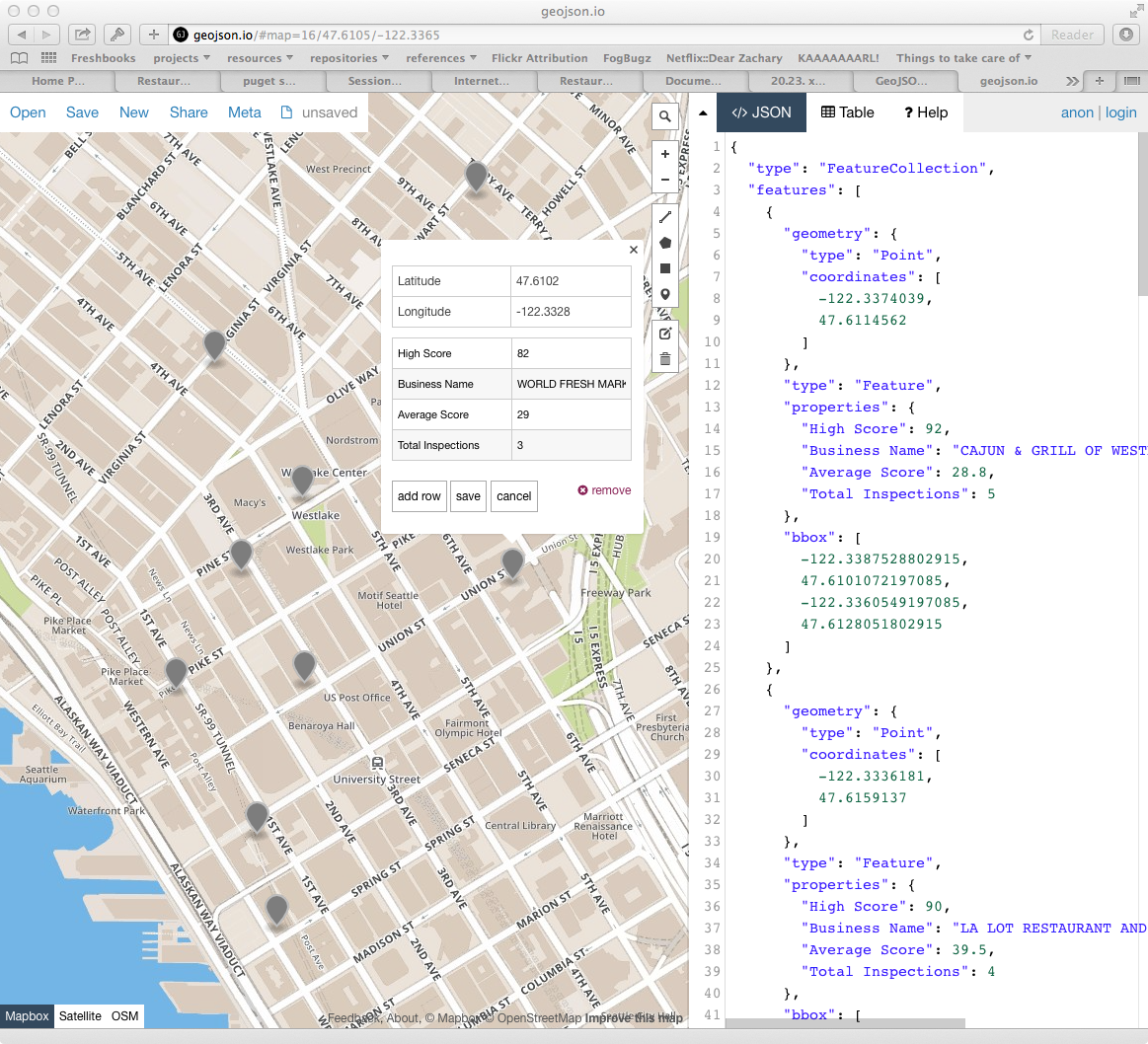
Once the new file is written you are ready to display your results. Open your web browser and go to http://geojson.io. Then drag and drop the new file you wrote onto the map you see there.
Going Further
Take a few more steps on your own to polish this mashup a bit.
Begin by sorting the results of our search by the average score.
Then, update your script to allow the user to choose how to sort, by average, high score or most inspections:
[souptests]
192:souptests cewing$ python mashup.py highscore
Next, allow the user to choose how many results to map:
[souptests]
192:souptests cewing$ python mashup.py highscore 25
Or allow them to reverse the results, showing the lowest scores first:
[souptests]
192:souptests cewing$ python mashup.py highscore 25 reverse
To simplify the passing of arguments from the command line, use the argparse module from the standard library to handle command line arguments
Next, try adding a bit of information to your map by adding marker-color to
the geojson properties dict. This will display a marker with the provided
css-style color (#FF0000)
See if you can make the color change according to the values used for the sorting of the list. Either vary the intensity of the color, or the hue.
Finally, if you are feeling particularly frisky, you can update your script to automatically open a browser window with your map loaded on geojson.io.
To do this, you’ll want to read about the webbrowser module from the standard library.
In addition, you’ll want to read up on using the URL parameters API for geojson.io. Click on the help tab in the sidebar to view the information.
You will also need to learn about how to properly quote special characters
for a URL, using the urllib quote function.